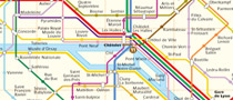
Paris Metro map
Taking the metro is quite easy in Paris. The first thing
visitors should do upon arrival is to get a free metro map at the hotel or in
any subway station. To plan your route before coming to Paris look at the subway
map to get acquainted with the city.
Here below is our selection of online resources about
Paris metro map.
Download PDF map
Plan your route before coming to Paris. Download the
PDF
subway map before your visit.
See: Download Paris metro map
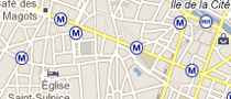
Subway stations & network on Googlemaps
Localize any subway station in Paris thanks to
Google maps. Click on and get details about lines.
See: Paris subway on googlemaps
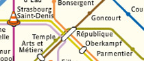
Paris metro interactive map
RATP official website provides a great interactive map
of the entire subway network.
See: Paris subway interactive map
Tips and informations: Ticket price, timetables, safety ...
Metro is one of the most convenient and cheapest way to get from
a place to another downtown Paris. Paris metro is the densest in the
world with about 300 stations concentrated in a small area. There are 14 lines numbered 1 to 14 each of
them beeing identified by a colour and name. The only two things to know for an
easy ride are line number and direction.
Please read our informations, tips and recommendations about safety,
tickets, timetables, transport strike...
Read more:
Paris Metro