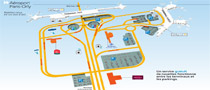
Plan aéroport Paris Orly Français

Orly airport map

Orly airport is the closest to Paris: It is located only 15km (9 miles) south of city center. Leaving the airport by car? The A6 motorway connects directly Orly airport to Paris city center (Porte d'Orleans or Porte d'Italie exits). Consider the roads map at the bottom of the page.
Please also find here below the official Orly airport map showing parking facilities, concourse maps, and on site hotels...

Orly airport shuttle service

Compare top airport transfer providers in Paris.
Read customers reviews and book your Orly airport transfer. Compare now to get the best rate

Orly airport shuttle service

Download Orly airport terminals map (PDF)

Download the official Orly airport map: Click on the link below or refer to Paris airport official website to get details about services in each terminal: Orly terminals maps
(Map courtesy of ADP)

Download PDF file

Plan your route before coming to Paris. To download Orly airport map please refer to official website.
See: Download Paris Orly airport map

Map - Road directions: Where is Orly airport located?

Other airports: Roissy airport map - Beauvais airport map

Compare airport shuttle providers
Adults
Child
Age
Shuttle-paris.com